
Revision Date: 2/10/2026
Eagle Mountain Site Guide
(This guide is not a substitute for a site introduction by an active MASA member)
Eagle Mountain is a heavily forested mountain that provides thermal and XC potential located 3 miles NE of Chewelah, WA (8 miles by road – 4WD and excellent clearance is advised with the National Forest’s current road condition). An extensive Forest thinning operation is scheduled for 2026 on Eagle Mountain and the road could often be closed. Check the Mountain Air Soaring Association website for current flying news & information.
Regulating Body: Mountain Air Soaring Assoc. Suitable for: HG & PG Direction of Launch: SSE - SSW Radio Frequency: 158.400 unless otherwise noted | Type of site: Mtn Flying: Thermal/Ridge GPS LZ: Seasonal |
USHPA Skill Level Recommendations: P3/H3 with mentor advised. P2/H2 with Site Intro mentor and light S wind conditions. Good knowledge of area geography/landmarks is required. You cannot see any of the LZs from launch.
Flying Season: values assigned 0-4 with 4 being the highest
Spring: 2 Summer: 4 Fall: 4 Winter: 1
Mild Conditions: Int. Moderate Conditions: Int. Strong Conditions: Adv.
MASA (Mountain Air Soaring Assoc.) defines the above conditions as follows: Mild: Ridge soaring days or lower wind non thermic days. Moderate: Ridge soaring days with moderate wind ranges, mild thermic days. Advanced: Ridge soaring days with higher wind ranges or gusting conditions. Moderate to extreme thermal days. Each pilot should evaluate the site conditions based on skill level and make their own decision based on skill.
| South Launch Wind Strength | Wind Direction (degrees) | ||||||||
| Min Req Rating | Wing Type | Min | Ideal | Max | Gust | Left | Right | ||
| H3 | HG | 0 | 10 | 18 | 10 | Ideal | 170 | 190 | |
| P3 | PG | 0 | 8 | 15 | 5 | OK | 160 | 200 | |
| Min Req Glide Ratio | Launch Alt (Ft ASL) | LZ Alt (Ft ASL) | Launch- LZ Dist (Feet) |
| 4.6/1 | 4400 | 2130 | 10,500 |
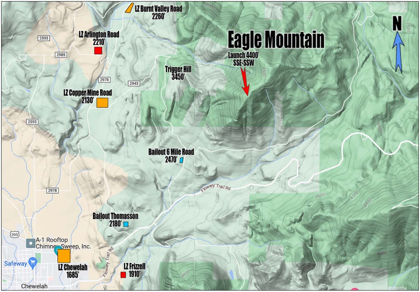
Description of Launch: SSE-SSW facing. Mountain meadow with plenty of room. Launch is at the center top of the meadow. SE and SW winds are to be avoided if the wind is 10 mph or stronger due to turbulence from trees to the E and W of the launch meadow.
Time to Fly: Sunrise until dusk. Sunshine @ the area’s sunrise will heat up the SE face of Eagle.
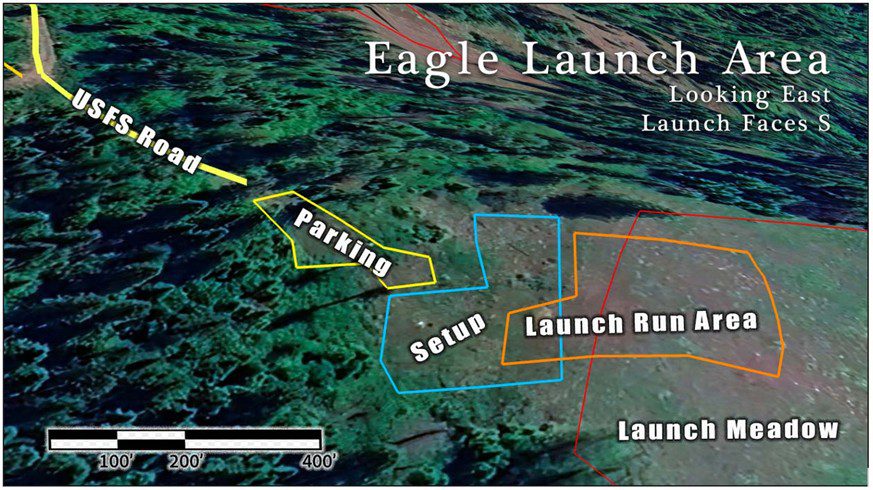
This map is looking East
Description of 3 Currently Used LZs:
Copper Mine Road LZ is the closest LZ with a vertical of 2270’ and a L/D of 4.6/1.
This LZ is a hay and cattle field open year round that is roughly 1000’ square with power lines on the N side and tall pines/firs on the E, S and W sides. Cattle may be in the field at times. Unless there are winds in excess of 12-15 mph first time pilots flying Eagle Mountain should land at this LZ. If the wind is in excess of 12-15 mph pilots are advised to land at the Burnt Valley Road LZ. Get to the LZ with some altitude to assess the direction to land depending on the conditions. Launch and landing conditions may well not be the same.
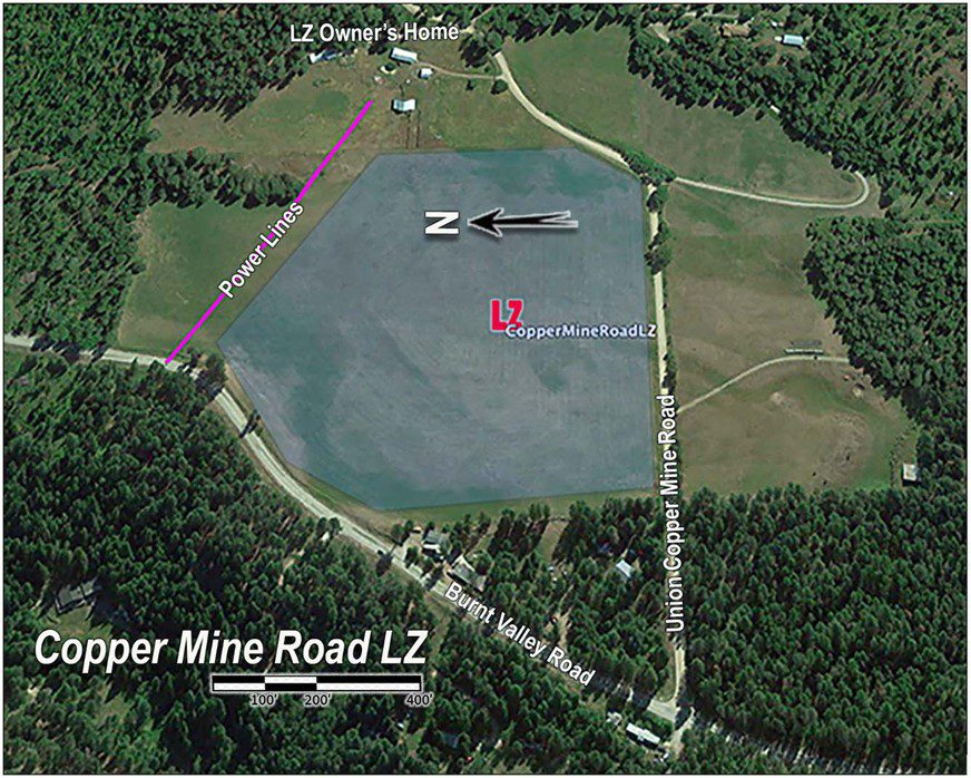
This map is looking East
Burnt Valley Road LZ (2260’ ASL) is the next closest LZ with a vertical of 2140' and a LD of 5.14/1. This LZ is a hay field open year-round that is roughly 1000’ long and 500’ wide with power lines on the N side and tall pines/firs on the E side (see map below). In S to SW winds exceeding 10 mph this LZ should be used. Launch and landing conditions may well not be the same. Parking can be made just off the dirt road and near the trees on the E side of the LZ.
Note: The dirt road going E-W through the LZ does not have any fences nor a gate. It is a driveway to 2-3 homes. There are powerlines along Burnt Valley Road but none go through this LZ. Pilots tend to do a downwind leg across the road to the N then turn right to come in over the trees to the E for base then right for final lining up parallel to Burnt Valley Road (S to SW).
This LZ is not easy to see when approaching on a glide from launch. Know the area so that you can tell where Burnt Valley Road is from the air. A good landmark to key off from is Trigger Hill.
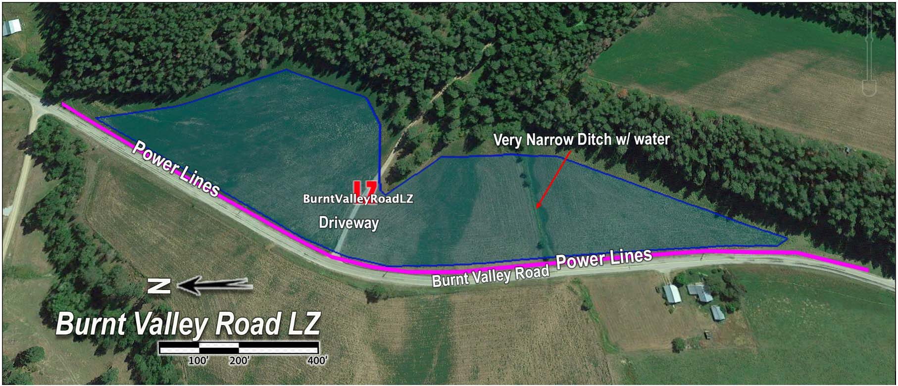
This map is looking East
Chewelah LZ (1690’ ASL) is the furthest LZ from launch with a vertical of 2710' and a glide ratio of 6/57/1. This LZ may be difficult to reach if you are flying into a S or SW headwind. The Chewelah LZ is an open cattle pasture. The pasture is larger than the area shown bounded by blue lines and the cattle are seldom in the LZ. This pasture can often be wet and especially in winter and spring. The cattle keep the grass low so the water can be seen. The wettest area is to the N of the LZ. Flags for wind direction indicators are at Jenkins High School to the S and SW of the LZ. The LZ is flat but cattle leave an uneven surface in areas. We usually park at the high school. This LZ is a 6.6/1 glide from launch but cannot be easily reached if you’re approaching in a SW headwind. The Chewelah LZ is often used on short XC (6-7 miles) flights from Inklers Point.
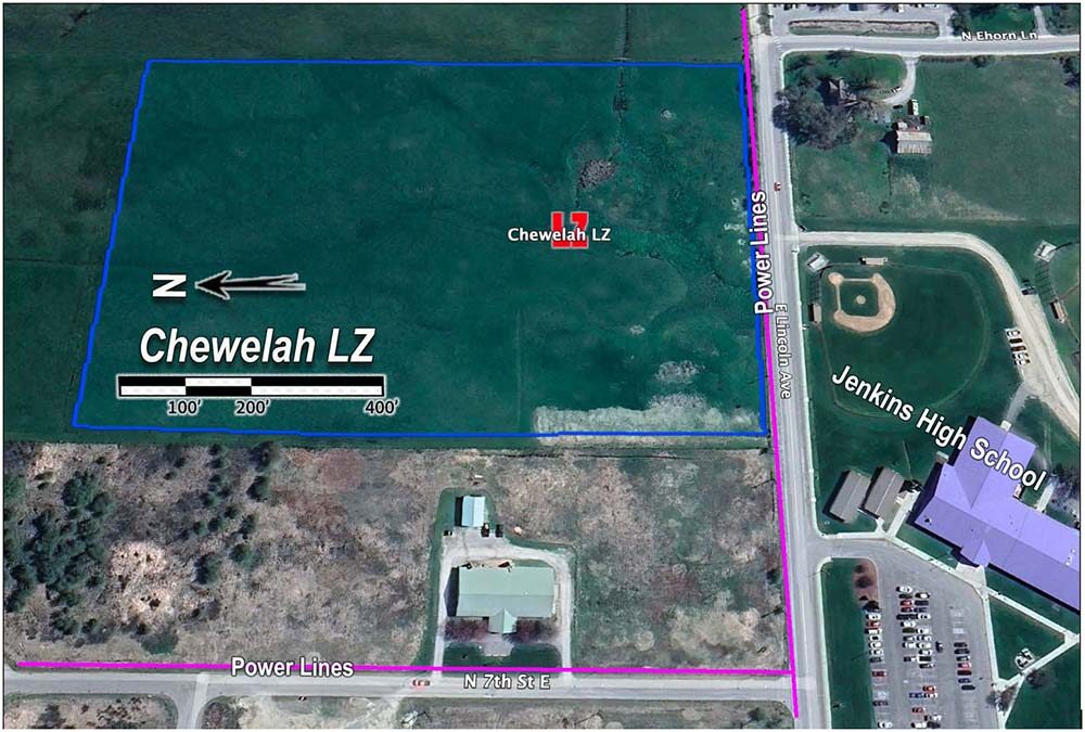
This map is looking East
General Site Map:
This map is looking North
Overview:
Eagle Mountain is best flown as a thermal site. The main face of Eagle Mountain is SE. The W end of Eagle Mountain has a S facing meadow which is Eagle’s South Launch. Soaring the SE face has not been attempted. Caution should be avoided in doing so since a SE wind will produce turbulence in the launch meadow. Also, a SE wind will be coming over Chewelah Peak which is SE of Eagle’s South Launch. The ideal wind direction is SSE-SSW for launching. The stronger the wind the more a direct S wind is desired.
The LZs cannot be seen from launch. Pilots flying Eagle Mountain need a good knowledge of the area’s topography and landmarks as well as the compass directions (study the map above). Once launched and not climbing pilots should turn W towards the Copper Mine Road LZ. It does not take long (well within a minute) to begin seeing the LZ areas. Pilots should not work the S area of Eagle Mountain and let themselves get low in this area. Chances of reaching any of the 3 LZs goes down if losing elevation in front of launch. Turning W after launching and working any lift off the W side of Eagle and in the Trigger Hill area, both closer to LZs, is a pilot’s best option to make it to one of the 3 LZs.
There are quite a few areas below Eagle’s South Launch to the SE, S, and SW where paraglider pilots can make adequate bailout landings. These open areas are not flat and the slope degrees can be deceiving from the air. Hang glider pilots should avoid landing anywhere other than the 3 LZs. The two bailout LZs (Thomason and 6 Mile) should not be used by hg pilots unless they have no other options.
Note: This site thas not been flown by many pilots and especially not many hg pilots. The hg pilot writing this site guide has flown Eagle 8 times over the past 10 years in a variety of wind, lift and seasonal conditions. There are 2 additional LZs colored in blue on the site map. Neither of these have been landed at yet and are not discussed in this site guide. Driving to launch requires going with someone who has been there and knows the road. There are roads on the way up that can easily be mistaken for the launch road without a guide.
Hazards:
Wind directions outside of SE to SW should be avoided at Eagle Mountain unless the conditions are light and variable (thermic conditions). In flight, if winds in excess of 15 mph are encountered out of the SSE to W the best LZ to use is the Burnt Valley Road LZ. It is in a small stream valley which the wind tends to funnel up. It offers the best chance to land into a stronger wind with less turbulence than the other LZs. Eagle Mountain is best flown in lighter conditions in winds not exceeding 15 mph. Go to Inklers Point if you want stronger ridge soaring conditions.
Check the Mountain Air Soaring Association website for flying and road conditions plus site status during fire season. MASA attempts to maintain both water and a shovel on launch; however, these items may not be present and do not substitute personal tools. Contact MASA for further information on this site.