Revision Date: 2/10/2026
Steptoe Butte Site Guide
Regulating Body: Mountain Air Soaring Association Suitable for: HG & PG Direction of Launch: 360* Launch Elevation: 3600’ ASL (approx) LZ Elevation: 2510’ ASL Site Regulation: Informal, Discover Pass, State Park Waiver Location: 1 hr S of Spokane, near Steptoe, WA Radio Frequency: 158.400 unless otherwise noted | Type of site: Mtn Flying type: Thermal/Ridge XC Potential: Fair LZ Coord: 47.0336, -117.2829 |
USHPA Skill Level Recommendations: P2/H2 before 11am & after 5pm during spring and summer. Fall and Winter can be flown during daylight hours.
Flying Season: Values assigned 0-4 with 4 the highest
Spring: 2 Summer: 3 Fall: 2 Winter: 1
Mild Conditions: Int. Moderate Conditions: Int. Strong Conditions: Adv.
COL defines the above conditions as follows: Mild: Ridge soaring days or lower wind non thermic days. Moderate: Ridge soaring days with moderate wind ranges, mild thermic days. Advanced: Ridge soaring days with higher wind ranges or gusting conditions. Moderate to extreme thermal days. Each pilot should evaluate the site conditions based on skill level and make their own decision based on skill.
Special Notice: Washington State Parks has closed Steptoe Butte for most of 2025 to do major road repaving and guard rail work. The Butte is not scheduled to reopen until February 13, 2026. We do not know if any new guard rails have impacted the use of launch areas.
Description of Launch: W Launch: Large Grassy slope with sporadic rocks. E Launch: Steep with sporadic rocks. SE launch: Trail with running area, sporadic rocks and bushes. NE Launch: Walk down from upper parking area, grass slope with a cliff band to the E and powerlines to the W.
Description of LZ: The LZ is an open field with minimal hazards, with S wind, a mild rotor may be present. Landings can be made on the road, or in any of the surrounding fields.
Time to fly: Daylight hours
East Launch
| Wind Strength | Wind Direction (degrees) | ||||||||
| Min Req Rating | Wing Type | Min | Ideal | Max | Gust | Left | Right | ||
| H2 | HG | 5 | 15 | 20 | 10 | Ideal | 55 | 95 | |
| P2 | PG | 5 | 10 | 15 | 10 | OK | 55 | 115 | |
| Min Req Glide Ratio | Launch Alt (Ft ASL) | LZ Alt (Ft ASL) | Launch-LZ Dist (mi) |
| 5.2 | 3610 | 2500 | 1.1 |
SE Launch
| Wind Strength | Wind Direction (degrees) | ||||||||
| Min Req Rating | Wing Type | Min | Ideal | Max | Gust | Left | Right | ||
| H2 | HG | 5 | 15 | 18 | 5 | Ideal | 95 | 120 | |
| P2 | PG | 5 | 10 | 14 | 5 | Ok | 90 | 145 | |
| Min Req Glide Ratio | Launch Alt (Ft ASL) | LZ Alt (Ft ASL) | Launch-LZ Dist (mi) |
| 5.4 | 3580 | 2500 | 1.1 |
S-SW Launch
| Wind Strength | Wind Direction (degrees) | ||||||||
| Min Req Rating | Wing Type | Min | Ideal | Max | Gust | Left | Right | ||
| H2 | HG | 5 | 12 | 20 | 7 | Ideal | 240 | 280 | |
| P2 | PG | 5 | 10 | 15 | 7 | Ok | 220 | 290 | |
| Min Req Glide Ratio | Launch Alt (Ft ASL) | LZ Alt (Ft ASL) | Launch-LZ Dist (mi) |
| 6.1 | 3540 | 2500 | 1.2 |
NNE Launch
| Wind Strength | Wind Direction (degrees) | ||||||||
| Min Req Rating | Wing Type | Min | Ideal | Max | Gust | Left | Right | ||
| H2 | HG | 5 | 15 | 20 | 5 | Ideal | 10 | 25 | |
| P2 | PG | 5 | 10 | 15 | 15 | Ok | 5 | 40 | |
| Min Req Glide Ratio | Launch Alt (Ft ASL) | LZ Alt (Ft ASL) | Launch-LZ Dist (mi) |
| 5.5 | 3610 | 2500 | 1.1 |
Site Directions: From Spokane, take Hwy 195 S, turn left on Hwy 127 through Oakesdale, turn right on Hume Rd, in 7 miles turn right on Steptoe Butte Rd. Take the Steptoe Butte Rd to the summit. There is a lower and upper parking lot. The State Park requires a WA State Discover pass which may be purchased on site. Steptoe is a popular tourist destination and sees moderate vehicle traffic. The road may not be maintained in the winter and can become icy. Watch for large tour buses in summer and obey all posted speed limits.
Site Guide:
(This guide is not a substitute for a site introduction by an active MASA member)
Steptoe is a fantastic flying location located in the middle of the scenic Palouse region. It offers flying experiences for both new and experienced pilots alike. With light wind extended sledders, ridge soaring, and thermal/XC opportunities it offers several different flying experiences. A WA State Discover pass and Parks waiver, listed above, are required to fly the site. Steptoe Butte is like an island in an ocean, the wind parts around it and meets on the other side. This may cause rotor which is listed in the hazard section below. The lower parking lot at the summit is the typical vehicle staging and gear set up area. There are guardrails present for HG pilots to tie off too. The lot is large enough for PG pilots to lay out and inspect their equipment. The SE facing launch can be accessed from this lower lot by a short trail. Several bushes and rocks are present on the takeoff run. Scout your launch run and angle prior to setting up. The S and SW launches are located on the side of a large grassy gentle slope. This is the primary launch as it aligns with prevailing winds and offers incredible slope soaring opportunities. Lay out can be done on the slope itself. Sporadic rocks and large bushes are present however there are plenty of clear paths. The N launch can be accessed from the upper parking lot. Several hazards including a cliff band to the E and power lines to the W are located on this launch. The launch itself is a moderate inclined grassy slope with minimal hazards in the takeoff run. The N launch does exit directly over trees so consider making your turn to the LZs early if no lift is available.
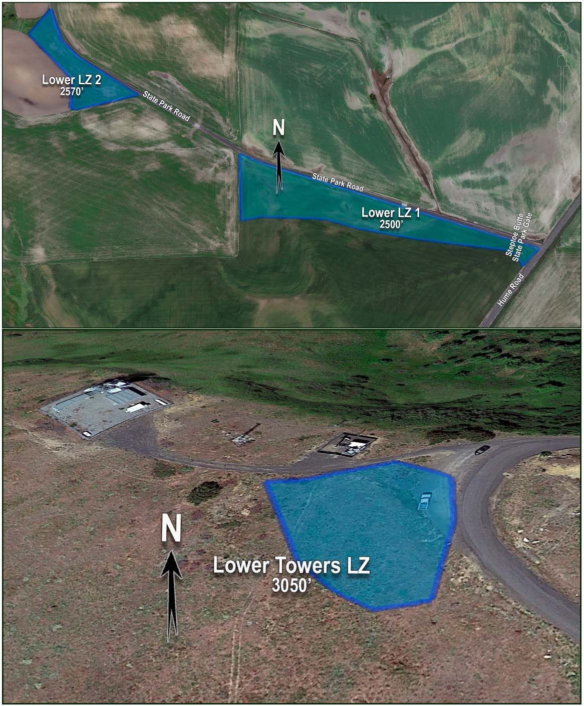
The LZs can be seen on the drive in on Steptoe Butte Rd. The Lower LZ 1 is located beside the road and is clear of hazards. Steptoe and the surrounding area are actively being farmed. Please be respectful of crops to the best of your ability. If you have to land out, the mountain is usually a short walk away. During spring, the LZ fields will be muddy, you can land on the main road however check for vehicle traffic prior to committing to an approach.
Hazards: Steptoe can be flown in all wind directions making it an excellent destination. Due to the shape of the cinder cone, in strong winds, it does produce rotor in the lee side and increased wind speed on its flanks. The ground is uneven and rocky in certain sections. It is recommended that you plan your launch route in advance. Pedestrian and vehicle traffic is increased during the flying season, plan accordingly when launching and landing. If flying in the winter keep in mind snow storms and road conditions may increase the risk of accessing the mountain. In the summer, the Palouse can produce strong thermals. Use local fields and environmental cues to fly safely.
Notes: Launches are on State Park land and cannot be marked for archeological reasons. Nor can the ground be modified. You’ll have to search for a good run. In SW to NW winds PG pilots occasionally land at the Lower Towers LZ (3050’). The Butte’s summit is at 3612’. The Lower LZs along the State Park Road are on private land. They may or may not be farmed. No driving is allowed off-roads in the entire area. Plan your landing area ahead of time. Be sure not to block concrete surfaced farm machinery access points when parking vehicles along the State Park Road.
Site Map: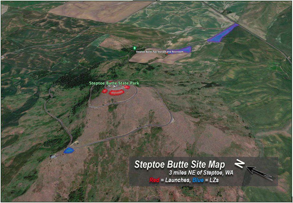
LZ Maps: