Revision Date: 2/10/2026
Parker Mountain Site Guide
Regulating Body: Mountain Air Soaring Association Suitable for: HG & PG Direction of Launches (2): SSE, S, SSW Pioneer Launch Elevation: 2950’ asl Parker LZ Elevation: 1640’ Site Regulation: Informal, Site intro required Location: 1 hr N or Spokane, near Chewelah, WA Radio Frequency: 158.400 unless otherwise noted | Type of site: Mtn Flying type: Thermal/Ridge XC Potential: Fair LZ Coord: 48.24535, 117.68575 |
USHPA Skill Level Recommendations: P2/H2 before 11am & after 5pm during spring and summer. Fall and Winter can be flown during daylight hours.
Flying Season: Values assigned 0-4 with 4 the highest
Spring: 2 Summer: 3 Fall: 3 Winter: 0
Mild Conditions: Int. Moderate Conditions: Int. Strong Conditions: Adv.
MASA defines the above conditions as follows: Mild: Ridge soaring days or lower wind non thermic days. Moderate: Ridge soaring days with moderate wind ranges, mild thermic days. Advanced: Ridge soaring days with higher wind ranges or gusting conditions. Moderate to extreme thermal days. Each pilot should evaluate the site conditions based on skill level and make their own decision based on skill.
Description of Launch: Lower (Pioneer) launch is a large South facing grassy slope. Upper (Jimmys) launch is a West facing cliff launch, MASA introduction is required.
Description of LZ: Both the LZs are open fields with minimal hazards located W of both launches. They are large farming fields usually growing hay. Water and high grass may be present in Spring and early Summer so it is recommended to scout the LZ prior to flying. High grass can obscure both water and barb wire fences. Bailout LZs can be seen from both launches. Bailout LZs are much more friendly to PG than HG as they are all sloped in a number of directions.
Time to fly: Daylight hours (In early AM hours and late PM hours beware of down slope winds).
Pioneer Launch (2950’)
| Wind Strength | Wind Direction (degrees) | ||||||||
| Min Req Rating | Wing Type | Min | Ideal | Max | Gust | Left | Right | ||
| H3 | HG | 0 | 10 | 15 | 10 | Ideal | 190 | 230 | |
| P3 | PG | 0 | 5 | 15 | 5 | Ok | 180 | 240 | |
| Min Req Glide Ratio | Launch Alt (Ft ASL) | LZ Alt (Ft ASL) | Launch-LZ Dist (mi) |
| 5.2 | 2950 | 1640 | 1.3 |
Upper (Jimmy’s) Launch (3333’)
| Wind Strength | Wind Direction (degrees) | ||||||||
| Min Req Rating | Wing Type | Min | Ideal | Max | Gust | Left | Right | ||
| H3 | HG | 0 | 10 | 15 | 10 | Ideal | 220 | 260 | |
| P3 | PG | 5 | 10 | 15 | 5 | Ok | 210 | 280 | |
| Min Req Glide Ratio | Launch Alt (Ft ASL) | LZ Alt (Ft ASL) | Launch-LZ Dist (mi) |
| 4.3 | 3340 | 1640 | 1.4 |
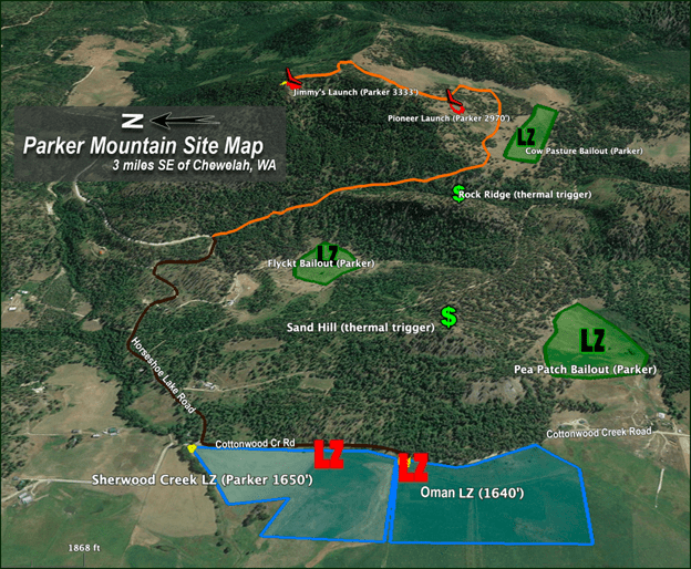
Site Directions: From Spokane, take Hwy 395 North towards Chewelah. Turn E on Hafer Road, Turn N on Cottonwood Creek Road, E on Horseshoe Lake Road. The LZ is marked with flagging and a windsock. A MASA member will lead the rest of the drive and have gate access.
Site Guide: (This guide is not a substitute for a site introduction by an active MASA member)
Parker is a unique flying location in the Chewelah Valley offering soaring, thermal, and XC potential. With two separate launches located on the property it can be used in a variety of wind directions. Several bailout locations located on the below map can be used if necessary. The Oman LZ, which should be scouted before proceeding to the launch, cannot be seen from either launch. The site may be closed during farming, hunting, or during fire season. Permission must come from the landowner in order to fly the site. During summer months, water and a fire extinguisher or firefighting tools must be carried at all times. Do not park in the tall grass. Contact MASA for flying permission and site intros.
Hazards: Upper (Jimmy’s) launch is a cliff launch and poses its own hazards. Terrain can mask a South aspect with the wind and may cause added rotor. A N-NW wind will cause rotor with the trees and cliff face. Heightened caution when launching must be taken. The LZ may be wet and full of tall grass in the early season. Scout the LZ prior to going to takeoff and locate a safe spot to land. If using the bailout LZs keep in mind they may be sloping and keep a sharp eye out for fences. The Flyckt Bailout is not suitable for hg – use only as a last resort.
Thermal Triggers and Sources: The valley below is a good source of thermals. So are the Pea Patch and Flyckt Bailouts. The N tree line of the Pea Patch is a good thermal trigger. So is Sand Hill (see map). Rock Ridge is the best trigger near the launches. Parker is best for thermal flying when winds are light.
Access: H2/P2 Pilots are to be accompanied by a H3/P3 pilot if they have not flown Parker previously. The launch road is gated and locked. Only pilots who have flown Parker will have gate access. The gate must be kept locked after each passage through it.
Additional Cautions: Become familiar with the topography before visiting Parker! Know the locations for Eagle Mountain’s LZs to the N. Be careful not to get low near either launch. Making the LZs in sink and a headwind will be very difficult if you get too low near steeper terrain. If wind exceeds 10 mph take flight paths that put you on the windward side of the topography. You will be visiting bailout LZs if you get too low near launches. Thermals can be found away from the mountain. Low saves near the LZ are not uncommon. Winds strong enough to ridge soar are turbulent. If flying N over to Quartzite Mountain - know the locations for Eagle’s LZs.
Parker Mountain Site Map: