
Revision Date: 2/10/2026
Inklers Point Site Guide
Regulating Body: Mountain Air Soaring Association Suitable for: HG & PG Direction of Launches: S, SW & W Top Launch Elevation: 2370’ asl Main LZ Elevation: 1670’ asl Site regulation: Permission, Waiver, Site intro required. The MASA online Calendar must be used. A new Waiver is being drafted. ALL individuals on the site will need to sign a new waiver. Contact MASA for more information. A new locked gate will also be added on the main S launch road in 2026. Location: 1 hr N of Spokane, 1.5 hr N of Spokane Valley, WA Radio Frequency: 158.400 unless otherwise noted | Type of site: Mtn Flying: Thermal/Ridge GPS LZ: Seasonal XC Potential: Good LZ Coord: 48.185419, -117.73081 |
USHPA Skill Level Recommendations: P2/H2 with mentor, P3/H3 otherwise – 1st time pilots @ Inklers require a site introduction by a MASA member familiar with the site (no exceptions!).
Flying Season: values assigned 0-4 with 4 the highest
Spring: 2 - Summer: 4 - Fall: 4 - Winter: 1
Mild Conditions: Int. Moderate Conditions: Int. Strong Conditions: Adv.
MASA defines the above conditions at Inklers Point as follows:
Mild: Ridge soaring days of 10-12 mph with a steady to near steady wind or lower wind non thermic days.
Moderate: Ridge soaring days with moderate wind ranges (10-15 mph), mild thermic days. Launch assistance as needed.
Advanced: Ridge soaring days with higher wind ranges and/or gusting conditions (15-25+ mph with launch assistance advised). Moderate to extreme thermal days. Each pilot should evaluate the site conditions based on skill level and make their own decision based on skill for the launch being used. Always fly within the USHPA recommended operating limitations for your rating as specified in the USHPA Pilot Proficiency System.
Note: Inklers is rarely flown in winds less than 10 mph. Once it gets to 10 mph it is often ridge soarable due to the ridge steepness. The lift band is usually tall which gets pilots above the ridge crest with ample room to follow ridge soaring right of way rules.
Note: Due to the topography of the ridge (knife edge like) pilots should avoid getting behind the crest when soaring above the top of the ridge. If the wind steadily increases pilots should fly in front of the crest as the lift band grows both in thickness and in height. If a pilot finds themselves in strong winds and getting behind the ridge crest with lack of penetration, it is best to fly NW towards the flat valley to land and thus avoiding encountering any leeside rotor of the ridge.
Description of Top Launch: SSW facing. Plenty of room at the top and a small slope that can be walked down to and launched from. Stay left at launch as more westerly winds may cause rotor. If the wind is due west use the West Launch.
Description of LZs: The Main and Railroad Bailout LZs at Inklers Point are large, flat grass fields with minimal hazards. There are no fences nor power lines near the Main LZ. There are barb wire fences associated with the Railroad Bailout LZ but they are easily seen, flagged, and far apart. There are no power lines near the Railroad Bailout LZ.
Time to Fly: Noon till dusk
| Top Launch Wind Strength | Wind Direction (degrees) | ||||||||
| Min Req Rating | Wing Type | Min | Ideal | Max | Gust | Left | Right | ||
| H2 | HG | 0 | 15 | 30 | 10 | Ideal | 175 | 205 | |
| P2 | PG | 0 | 10 | 20 | 10 | Ok | 165 | 270 | |
| Min Req Glide Ratio | Launch Alt (Ft ASL) | LZ Alt (Ft ASL) | Launch- Lz Dist (mi) |
| 2.3 | 2170 | 1670 | 0.5 |
Description of West Launch: W facing. Grassy and wildflower slope with trees to the N & S and behind (top area). Some large rocks and stumps are off to the sides before the trees. The main launch run, a slot launch, is free of the rocks and stumps. If launch run vegetation is higher than 6” it should be cut or the slope walked to be sure of no hidden branches or rocks. Attention should be paid to the windsocks in the LZ for cross winds and thermic conditions. Care should also be taken to make sure pilots who may have launched from either the Original or Top launches are soaring near you when you launch.
Description of LZs: The center of the Main LZ is directly in front of this launch.
Time to Fly: Noon till dusk
| West Launch Wind Strength | Wind Direction (degrees) | ||||||||
| Min Req Rating | Wing Type | Min | Ideal | Max | Gust | Left | Right | ||
| H2 | HG | 0 | 12 | 20 | 5 | Ideal | 260 | 270 | |
| P2 | PG | 0 | 10 | 15 | 5 | Ok | 240 | 300 | |
| Min Req Glide Ratio | Launch Alt (Ft ASL) | LZ Alt (Ft ASL) | Launch- LZ Dist (mi) |
| 2.3 | 2020 | 1670 | 0.15 |
Description of Original Launch: S facing. Grassy and wildflower slope ending at a cliff. If launch run vegetation is higher than 6” it should be cut or the slope walked to be sure of no hidden branches or rocks. Note: The LZ for this launch is the Railroad Bailout LZ directly in front of and below launch. You can easily make the Main LZ if you are soaring the ridge. If you are not soaring the glide ratio to the Main LZ is 5.5/1 and you are most likely flying up wind. Keep in mind that you can land in the Railroad Bailout area. Attention should be paid to the windsocks in the LZ for cross winds and thermic conditions. Care should also be taken to make sure pilots who may have launched from either the Top or West launches are soaring near you when you launch. Note: When the wind at this launch is SW or further W a rotor sets up on the right side of launch. In SW to W conditions, and especially stronger winds, you should be at either the Top or West Launches. Pay close attention to wind direction. Note: If the wind becomes more SE this launch is still pretty good to use. However, you should be wary of landing in the Main LZ in SE conditions as the wind may be coming over the S end of Inklers Point and down in the Main LZ area. It is best to have the Railroad Bailout LZ as your first option for landings and only land in the Main LZ if you can easily soar Inklers Point to the E from this launch.
Description of LZs: The Railroad Bailout LZ is directly in front of this launch.
Time to Fly: Noon till dusk
| Original Launch Wind Strength | Wind Direction (degrees) | ||||||||
| Min Req Rating | Wing Type | Min | Ideal | Max | Gust | Left | Right | ||
| H2 | HG | 0 | 12 | 30 | 10 | Ideal | 170 | 200 | |
| P2 | PG | 0 | 10 | 20 | 5 | Ok | 165 | 220 | |
| Min Req Glide Ratio To Bailout LZ | Launch Alt (Ft ASL) | LZ Alt (Ft ASL) | Launch- LZ Dist (mi) |
| 2.2 | 2150 | 1670 | 0.20 |
Site Directions:
From Spokane: N on Hwy 395, Left on Hwy 231 (Bulldog Creek Rd), After passing the entry to the quarry which is approx 2.5 mi. The entrance to the site is approx 100yds from the quarry entrance on the left and is marked by flagging. The site is located on Google Maps.
Do not park in tall grass during high fire danger
(5 gallon water spray containers are located at the Top Launch and E Main LZ Parking areas)
A site mentor will show you the route to the launch during orientation. 4wd is highly recommended (steep upper sections) however 2wd with good ground clearance is acceptable when the launch road is in good condition.
Site Guide Summary:
(This guide is not a substitute for a site introduction by an active MASA member)
Inklers Point is a mountain that provides ridge soaring, thermal, and cross country potential located 6 miles south of Chewelah, WA. The site is a USHPA insured site. The site requires a valid USHPA Membership, site intro, local site waiver ( Waiver_23) and the Online Inklers Calendar filled out in order to fly. Contact MASA for further information. See bottom of this Guide for the Calendar link.
Overview: Refer to the Site Map below. The Inklers Point Ridge has three launches: Top, West & Original. The Top & West Launches are accessible via vehicles and the Original Launch can be accessed from the top after a brief walk or from a bottom trail. The Top (2370’) & Original (2150’) launches work best with a SSE-SSW wind direction (ideally straight into the Top Launch). Ideal wind speeds are 10-12 mph for PG and 12-15 for HG. The Top Launch works with SSE-WSW winds. Top Launch offers a slope that pilots may walk down and take off at a lower level if necessary. The West Launch (2020’) is best in a W wind with a 10-15º right or left Ok span.
The LZ can be seen from all launches and is shown on the map in blue. The Railroad Bailout area is shown in green. Additionally, pilots may land in any of the open fields in the event of an emergency. There are minimal hazards located in the LZs. It is not uncommon for the wind to be 5 mph or less in the main LZ while remaining soarable on the ridge. Beware of wind gradients while flying and landing. There are no amenities at the site however a gas station is located approx 4 mile farther North. Chewelah offers several fine restaurants, fuel, and watering holes after a long day of flying. Current weather for the site can be found here: https://www.wunderground.com/personal-weather-station/dashboard?ID=KWAVALLE8
Hazards: Westerly winds should be avoided at the Original Launch and cautioned at the Top Launch. SW and WSW winds should raise caution in pilots as they may cause rotor on the Original launch. Both launches have small cliff sections and caution should be used. The ridge itself is relatively small and may become crowded with several pilots in the air if soaring conditions a light. Standard traffic patterns apply and practice due diligence when flying with others. During fire season, a shovel, fire extinguisher, and a minimum of 5 gal of water is required per vehicle. Check the Mountain Air Soaring Association’s website (mountainairsoaring.org) for flying conditions and site status during fire season. MASA attempts to maintain both water and a shovel on launch; however, these items may not be present and do not substitute personal tools.
No fires nor pets are allowed at Inklers and camping needs to be cleared through the club and landowners prior to being allowed. Contact Mountain Air Soaring Association through our website or for further information on the site.
Inklers Point Site Map: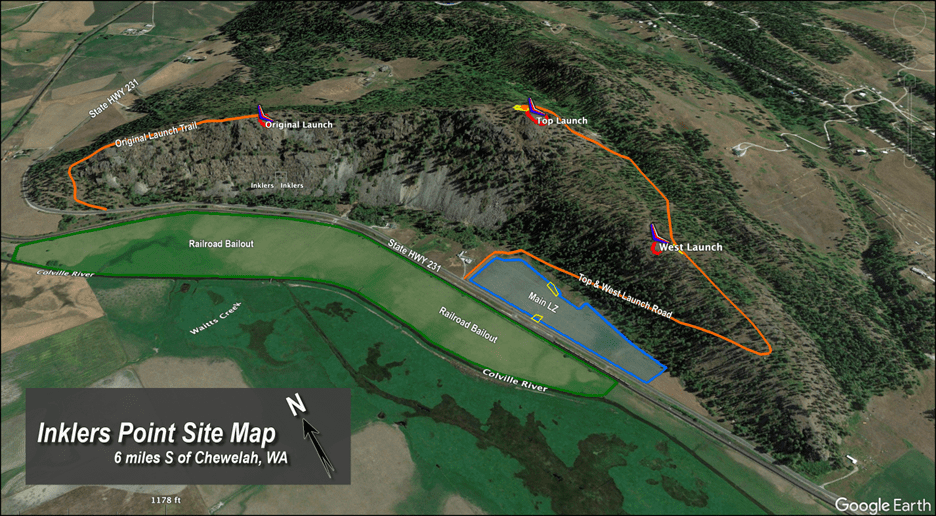
Launches noted in red with hg icons
Main LZ noted in blue
Railroad Bailout LZ noted in green
Trail to Original Launch noted in orange
Parking noted in yellow